


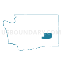
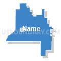
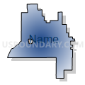
Lind Rural Voting District, Adams County, Washington
About
Outline

Summary
| Unique Area Identifier | 683347 |
| Name | Lind Rural Voting District |
| County | Adams County |
| State | Washington |
| Area (square miles) | 148.80 |
| Land Area (square miles) | 148.77 |
| Water Area (square miles) | 0.03 |
| % of Land Area | 99.98 |
| % of Water Area | 0.02 |
| Latitude of the Internal Point | 46.99097370 |
| Longtitude of the Internal Point | -118.51076730 |
Maps


Graphs
Select a template below for downloading or customizing gragh for Lind Rural Voting District, Adams County, Washington


Neighbors
Neighoring Voting District (by Name) Neighboring Voting District on the Map
- Batum Voting District, Adams County, WA
- Cunningham Voting District, Adams County, WA
- Fairview Voting District, Adams County, WA
- Lind Voting District, Adams County, WA
- Ralston Voting District, Adams County, WA
- Ritzville Rural Northwest Voting District, Adams County, WA
- Ritzville Rural Southeast Voting District, Adams County, WA
- Schrag Voting District, Adams County, WA
- Washtucna Rural Voting District, Adams County, WA
Top 10 Neighboring County Subdivision (by Population) Neighboring County Subdivision on the Map
Top 10 Neighboring Place (by Population) Neighboring Place on the Map
Top 10 Neighboring Unified School District (by Population) Neighboring Unified School District on the Map
- Ritzville School District, WA (2,388)
- Lind School District, WA (1,185)
- Washtucna School District, WA (313)